Showing posts with label Santa Clarita History.. Show all posts

Friday, November 20, 2015

Mentryville,Historic Oil Town


The Santa Clarita Valley was practically built on Oil.  The rich deposits from Placerita, to Pico,to Elsmere Canyons had oil wells dotting the landscape for years. 

Mentryvville is a famous oil town in the West Santa Clarita Valley which has been preserved over the years. While there are no longer any residents of this town the remnants of this historic oil town are still around and available for the public to see.

The Schoolhouse
SDC11659SDC11664

SDC11662When you gotta go, you gotta go….


The foundation of an old building, SDC11678


Oil drilling equipment.
SDC11668


SDC11670

SDC11674SDC11669


A marker for Pico #4 the first commercially successful oil well in the western united statesSDC11675


Up the hill to Odeen #1. 
SDC11895SDC11893


The marker for Odeen #1.  A less than successful well but a spectacular view.
SDC11884SDC11891

Tuesday, October 13, 2015

Santa Clara River Bridge Remains


The St. Francis Dam failure in 1928 was devastating.  The loss of life and property extended for miles.  The remains of the dam still exist but there are some other ruins from this terrible event that can be found as well.

The Santa Clara River bridge was part of the original ridge route which extended from Los Angeles to Bakersfield.  It crossed the Santa Clara river at what was then Castaic Junction.  The bridge there was washed out when the flood waters from the dam failure came through but the concrete supports and some evidence of the old ridge route still survive.

I decided to venture out and find this historic site.  It's amazing that after all these years this site still exists.


Below is a postcard depicting the bridge while still in tact.


The same area today.
IMAG0649


This is the asphalt from the original ridge route where it would have met the bridge
IMAG0646

IMAG0635


Bridge supports
IMAG0632
IMAG0633
IMAG0641
IMAG0642

Saturday, October 10, 2015

Abandoned Oil Refinery/Beale’s Cut


These days the Santa Clarita Valley can be accessed from the south via the 14 and 5 freeways or The old road and Sierra highway. Back in the mid 1800’s the first path through what is now the Newhall Pass was Beale’s Cut.  A crude path cut through the mountain but an important throughway that allowed people to gain access to the Santa Clarita Valley.

Beale’s Cut still exists although it is somewhat challenging to get to.  Access from the south is somewhat available although it has become increasingly overgrown.  Access from the north requires you to pass through what is left of the Newhall Refinery property which is connected to the Elsmere Canyon open space. 

To find out more about this historical site please visit http://www.scvhistory.com/scvhistory/bealescut.htm


Below are some photos and video of my trek to this historic site.

Newhall refinery in the 50s                       and today
refinery1959aSDC11909

SDC11921SDC11923
SDC11910SDC11911


Beale’s Cut today
Beale's Cut
A link to a photo of the same area in the 1870s http://www.scvhistory.com/gif/ap0625.jpg


A view looking north from inside the cut
Inside Beale's Cut
And a view looking south from inside the cut
SDC11916


A little video of the decent from Beale's cut back through the refinery.

Saturday, July 4, 2015

St. Francis Dam disaster

The St. Francis Dam disaster was one of the worst engineering failures in California history.  On March 28th 1938, the St. Francis Dam failed and collapsed.  A wall of water flowed through San Fransicquito canyon, through the Castaic Junction, Fillmore, Santa Paula and finally ended up in the pacific ocean.

Growing up in Southern California I don’t recall ever hearing about this, I guess it wasn't a proud moment in California History.  As an adult living in the Santa Clarita Valley I became interested in the history of the surrounding areas.  After reading up on the disaster and the history of the site I decided to go check it out for myself.  It’s hard to believe that the site and the remains of the dam have just been sitting there off San Fransisquito Canyon road for nearly 90 years.

Below are some pictures I took from three different trips out to the site between Feb and Nov  2014


SDC11701SDC11697SDC11700


Someone was nice enough to let you know when get there and when you pass  the site.


DSCN1670SDC11716


This is the top of the west ridge. The remains are far less weathered up here.
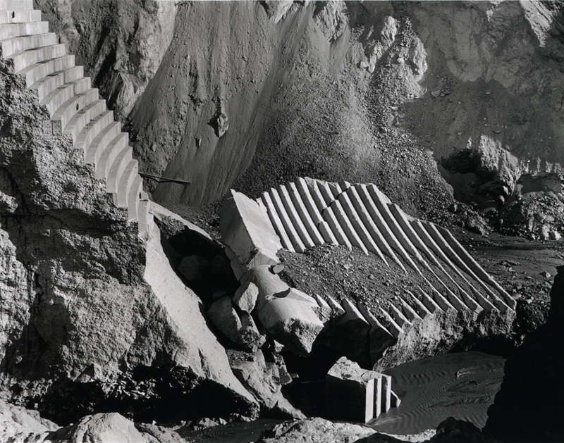
 DSCN1681DSCN1700
DSCN1693

This huge rock like structure is actually a large piece of the dam. This is about 1/4 mile down the river bed from the dam site.  I'd say it's about the size of a two story house.
DSCN1702

You can line up this last shot with the shot right after the dam failed linked below. Note the dark rubble on top of the stepped concrete.
 SDC11728

http://www.scvhistory.com/gif/al3030.jpg


This is an interesting trip and not a long hike.  If you’re interested in learning more about this site and the history please visit the link below
http://www.scvhistory.com/scvhistory/stfrancis.htm